REVIEW · YEREVAN
Aragats Mountain Hiking Tour
Book on GetYourGuide →Operated by Red Hat Tours · Bookable on GetYourGuide
Aragats Mountain turns a hike into a geology lesson. Starting near Stone Lake at 3200m, you walk through the crater story of the “four-headed” Aragats, then push to the South Peak at 3888m for big, clear views across the Ararat Valley.
I love how the day is built around real altitude and real payoff. And I especially like the way the guide helps you feel steady on uneven, sometimes snowy ground, with Yeva showing up in multiple recent experiences as calm, safety-minded, and encouraging.
The one thing to consider: this is a challenging hike. With about 700m elevation gain over roughly 13km and fast-changing weather, you’ll want proper layers and good hiking shoes, not just a good attitude.
In This Review
- Key highlights to know before you go
- Why Aragats feels like Armenia’s own secret sky
- From Republic Square to Kari Lake: a high start that pays off
- The climb to South Aragats Peak (3888m) without drama
- Why the geology explanations make the summit feel better
- The summit moment
- Amberd Fortress at 2300m: history you can reach with tired legs
- Guide energy matters: Yeva, safety, and the right pace
- What “perfect pace” usually means in practice
- Transportation, timing, and what to pack for this altitude day
- Price and value: $176 for a full mountain + fortress day
- What to bring (because weather can change fast)
- Who should book this Aragats hike?
- Should you book Red Hat Tours for Aragats?
- FAQ
- How long is the full Aragats Mountain Hiking Tour?
- What’s the hike duration and difficulty level?
- Where does the tour start and end?
- What is included in the tour price?
- Is lunch included?
- What languages does the live guide speak?
- How many people are in the group, and can I cancel?
Key highlights to know before you go
- Stone Lake at 3200m: start high, with Kari Lake scenery and an easy warm-up feel before the climb
- The four-headed Aragats story: crater and eruption history explained while you’re standing in the evidence
- 3888m South Aragats Peak views: big all-around panoramas toward Ararat and neighboring mountains
- Amberd Fortress at 2300m: a 7th-century site reached after the summit effort
- Small group energy (up to 10): more attention from the guide, and a pace that won’t leave you behind
- Safety focus on rough conditions: recent hikers praised guides like Yeva for keeping the route and footing sensible
Why Aragats feels like Armenia’s own secret sky
Aragats isn’t just famous because it’s the tallest mountain in Armenia. It’s famous because the mountain looks like it has multiple faces. From the way the slopes break into distinct forms, you get why people call it the four-headed Aragats.
What makes this tour special for me is that you don’t just walk to a top number. You understand what you’re seeing as you go. You start at Kari Lake (Stone Lake) at 3200m, then climb toward the crater area that ties back to an ancient eruption. When you finally get to the summit at 3888m, the views make sense, because you’ve already been told the mountain’s story while standing in the right place to picture it.
And yes, you’ll feel it in your legs. But that’s the point. This is the kind of day where, when you’re back in the city, you keep replaying the best angles of Aragats and the stretch of horizon you saw from the top.
From Republic Square to Kari Lake: a high start that pays off
Most full-day trips start with a long drive and a sleepy beginning. This one starts in a more useful way: you begin at Republic Square and head out to Kari Lake at about 3200m.
On the way, you get scenic views and a guided component, so you’re not just traveling—you’re already learning. At Kari Lake, the tour includes a guided visit plus a panoramic train ride. That matters more than you might think. At altitude, time and energy feel different. The train ride helps you get set up visually and physically before the main hike.
Kari Lake itself, called Stone Lake, is more than a scenic photo stop. It’s your doorway into the geology of Aragats. The guide’s job here is to connect the crater landscape you’ll soon approach with the volcanic origin behind it—so when you later see how the terrain unfolds, your brain doesn’t treat it like random rock.
A practical note: you’ll feel the altitude early. You don’t need to panic or slow to a crawl, but you should take water seriously and pace yourself right away.
The climb to South Aragats Peak (3888m) without drama
Here’s the reality of the main hike: you’re walking about 13km with around 700m of elevation gain. The hike portion runs roughly 5 to 6 hours, but the total day runs about 8 to 9 hours when you add the driving, stops, and the return trip.
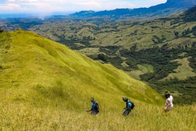
The route starts at Stone Lake (3200m) and leads you to the South Aragats Peak, the highest point on this hike at 3888m. Along the way, there are photo stops and guided sections, which helps break up the climb into manageable chunks.
What you’ll likely notice first is how the terrain changes with altitude. Lower down, the hike can feel like steady uphill through rough ground. Higher up, conditions can turn faster—wind, cold, and even snow or hail can show up unexpectedly. One recent hike described hail on the ascent, which is a reminder to treat weather as an active participant in the plan, not a background detail.
Why the geology explanations make the summit feel better
The tour doesn’t treat the mountain like a checklist item. It explains the ancient eruption that formed the crater, including the crater’s depth (about 400m). Whether you’re a science person or not, that detail gives you something to hold onto during the climb.
You’re not just going up to say you did it. You’re going up with a mental picture: crater shape, volcanic formation, and why the summit area looks the way it does. That’s why the views from the top land differently. You recognize the scale and you start to understand the mountain as a system, not a single peak.
The summit moment
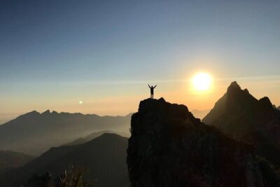
At the top, you’ll have a rest and time for all-around views. The tour highlights include sightlines toward the Ararat Valley, Mount Ararat, and the neighboring Araler Mountain range. From 3888m, that kind of panorama can feel like staring at a whole country map made of weather and rock.
Also, pay attention to the social side of the summit. One set of hikers talked about a brunch moment at the peak. Even if your day doesn’t include exactly that, the tour’s pacing includes time to stop, breathe, and enjoy the summit without feeling like you’re being rushed straight back down.
Amberd Fortress at 2300m: history you can reach with tired legs
After the summit, you continue your journey to Amberd Fortress, located at about 2300m. This is a 7th-century castle, and it’s a smart pairing with the hike because it gives your body a change of rhythm without turning the day into a pure recovery session.
Amberd works best when you arrive with your senses already activated. You’ve been outside all day, you’ve been dealing with altitude, and now you’re looking at stone structures from another era. Photo stops and guided context help you understand what you’re looking at and why the fortress sits where it does.
One of the best parts of this half of the day is that you get both extremes: volcanic height at 3888m, then fortress at 2300m. The switch makes the day feel complete. You finish by seeing not just mountain nature, but also the human history that depended on these strategic high places.
When you return to Yerevan at the end of the day, it doesn’t feel like you simply went hiking. It feels like you did two different chapters of Armenia in one outing.
Guide energy matters: Yeva, safety, and the right pace
If you’re choosing between similar hikes, here’s what I’d prioritize: the guide’s approach to safety and pacing. This tour is built as a small group experience, limited to 10 participants, which already helps, because you’re less likely to get lost in the shuffle.
Recent feedback highlights guide Yeva specifically. People praised her for making snow hiking feel safe and manageable, and for staying attentive to pace and comfort. That kind of calm, steady energy matters on a mountain where footing can change quickly.
Other recent hikers also called out that the guide chooses routes and footing with care, not just speed. One person even mentioned that the guide helped them feel confident by selecting the proper footing for safety while still keeping the views front and center.
What “perfect pace” usually means in practice
You should expect a rhythm that balances effort with stops. The tour includes guided segments and photo pauses, so you’re not stuck grinding uphill for hours without breaks. Still, don’t expect an easy stroll. About 700m gain over roughly 13km means your body will work.
If you’re a first-timer, the best strategy is to focus on steadiness, not speed. A guide who pays attention to the group can help you avoid the common mistake: going too fast early and suffering later.
Transportation, timing, and what to pack for this altitude day
Logistics are part of the experience here, because the mountain day starts early enough to feel like an all-day event.
You’ll spend time traveling from Republic Square to the starting area near Kari Lake, then hike to the summit, then move on to Amberd Fortress, and finally return to Yerevan. The total day length is about 8 to 9 hours.
Price and value: $176 for a full mountain + fortress day
At $176 per person, you’re paying for a guided hike, transportation, and entry to Amberd Fortress. Water is included.
Lunch is not listed as included. That means you should plan for food you can manage on a mountain day—something snack-sized and altitude-friendly. One recent review did mention brunch at the peak, but don’t assume that’s guaranteed every time. Treat it as a possible extra, and plan your own basic nutrition regardless.
Is $176 “cheap”? No. But for a guided, high-altitude summit hike plus a separate historical site at altitude, it looks like fair value. You’re paying for expertise and organization, not just motion.
What to bring (because weather can change fast)
The tour notes that weather can change rapidly, so dress accordingly. That’s not a vague warning. At this altitude, you should assume wind and cold can arrive fast. I’d pack layers you can add or remove, and hiking shoes with good grip. Gloves and a hat are also sensible if conditions turn icy or snowy.
Also, drink water even when you don’t feel thirsty. Altitude can quietly change your hydration needs.
Who should book this Aragats hike?
This tour is a strong match if you want:
- A challenging day outdoors with a clear summit goal
- A guided experience that explains the geology while you’re there, not after you’re back down
- Big views toward Mount Ararat, plus a stop at Amberd Fortress afterward
- A small group format (up to 10) with more guide attention
You might think twice if you’re very new to hiking or you’re unwilling to handle rough footing and altitude-driven weather changes. The hike is graded by effort, not by comfort.
If you are the type who likes earning your views and learning along the way, you’ll likely love this day.
Should you book Red Hat Tours for Aragats?
I’d book it if your priority is a well-structured mountain day that ends with a meaningful historical stop. The combo is the selling point: summit effort at 3888m, then Amberd Fortress at 2300m, all with a guide and transportation keeping the day focused.
I’d also book it because recent hikers repeatedly praised guides like Yeva for safety and pacing—exactly what you want on a hike where weather can turn. This is the kind of tour that feels like it was designed for real movement, not just sightseeing.
If you have the right gear and you’re comfortable with a tough walk, this tour is one of the best ways to see why Aragats is called the four-headed mountain—and to come home tired, impressed, and already thinking about the next climb.
FAQ
How long is the full Aragats Mountain Hiking Tour?
The tour runs about 8 to 9 hours total.
What’s the hike duration and difficulty level?
The hiking portion takes about 5 to 6 hours, with roughly 13 km of distance and about 700 m of elevation gain.
Where does the tour start and end?
You start at Republic Square in Yerevan and return there at the end of the day.
What is included in the tour price?
Included are guide services, transportation, entrance tickets to Amberd Fortress, and water.
Is lunch included?
Lunch is not listed as included.
What languages does the live guide speak?
The live guide is available in Arabic, Armenian, English, French, German, Italian, Polish, Russian, and Spanish.
How many people are in the group, and can I cancel?
The group is limited to 10 participants. Cancellation is free up to 24 hours in advance for a full refund.